Introduction
The Bikeway Element of the Transportation Action Plan (TAP) serves to expand and enhance Scottsdale’s on-street and paved path network to provide safe and inviting access for pedestrians, bicyclists and other non-motorized users to travel to destinations in Scottsdale and neighboring communities.
The City of Scottsdale currently maintains a robust network of on-street and off-street bike facilities, including bike lanes, bike routes, shared use paths and paved roadway shoulders (see Figure B-1).
Scottsdale’s street system provides the most direct access to nearly all destinations in the city for active transportation users via bike lanes and bike routes. These bike lanes and bike routes allow users direct access to the off-street shared use path network. City’s design guidelines for arterial and collector streets are found in the Design Standards and Policies Manual (DS&PM). These facilities include bike lanes, sidewalks, and trails and are typically included with new construction and major reconstruction projects. New or modified bike lanes can also be installed when streets are restriped with pavement management projects.
The off-street network consists of paved shared use paths and unpaved shared use trails. Trails are discussed in the Trail Element of this TAP. All shared use paths and side-paths (adjacent to streets) are open to all non-motorized users. Shared use paths represent an important component of the overall bike network. They provide opportunities to ride for users who may not be comfortable riding in the roadway, such as casual cyclists, children, families and older adults.
Goals
- Build bike facilities that form a continuous network with seamless connections to public transit, schools, neighborhoods, community destinations and the regional bike network. Special consideration will be given to emerging concepts and infrastructure that increase the comfort and confidence level of all riders.
- Implement education, encouragement and data collection programs to increase bike usage and improve bike safety.
- Expand the network of on-street and off-street bike facilities to increase the amount of biking for all trip purposes.
- Provide access to a shared use path within ½-mile of all residences, unless privately owned property or natural terrain make it impractical.
- Maintain and enhance the current bike transportation network to meet current design standards.
- Achieve a Platinum-level Bicycle Friendly Community certification from the League of American Bicyclists (LAB).
Policies
- Construction Priorities: Completion and renovation of the three primary shared use paths (Arizona Canal/Cross Cut Canal, Central Arizona Project Canal and Indian Bend Wash), followed by other paths that improve regional connectivity, will be prioritized for use of capital improvement funds and grant requests. Side paths next to streets should be incorporated into improvement plans for collector and arterial streets.
- Roadway Restriping: Improve on-street bike accommodation and bicyclist and pedestrian comfort through striping changes that consider historic and forecasted motor vehicle traffic, center turn lane requirements, existing pavement width and existing lane widths. This restriping protocol will typically be applied when roadways are being treated through standard pavement preservation applications and will incorporate buffered bike lanes where feasible.
- Neighborhood Bikeways: Develop Neighborhood Bikeways on low-volume, low-speed roadways to be used by a wide range of bicyclist abilities. Improvement options should consider traffic calming and enhanced roadway crossings.
- Wayfinding: Implement a cohesive wayfinding system directing people to and along shared use paths and Neighborhood Bikeways and to community destinations.
- Intelligent Transportation Systems (ITS): Identify and test solutions that balance traffic flow with improved bicycle mobility in key corridors.
- Education and data collection: Promote bicycling’s benefits for health, recreation, transportation and tourism. Evaluate bicycle usage counts on the network to establish trends and prioritize outreach and improvements.
- Safety and Enforcement: Inform the public (motorists, bicyclists and pedestrians) about bicycle, vehicle and pedestrian operation on streets and paths. Work with public safety staff to improve enforcement of traffic laws related to biking. Collect, analyze and report on bicycle collision data on a regular basis and develop remediation measures to address high-frequency and high-volume collision locations. Support Safe Routes to School programs. Support the use of grade separated crossings at barriers such as freeways and arterial roadways and along large drainageways.
On-Street Bikeways
The on-street bike system will continue to expand and improve as new roadway segments of minor collector size or larger are constructed. New construction will follow the standard cross sections already in place or identified for revision through the TAP, and as mentioned above, potential new bike lane restriping efforts will be coordinated with the city’s pavement management program.
As noted in the Street Element, minor collectors that do not require a center turn lane will also be a focus area for adding improved bike lanes, typically with painted buffers. Constructed bike lane buffers will also be assessed based on applicability, safety, cost and maintenance issues.
Most bikeway system improvements resulting from travel lane reductions would occur through striping changes coordinated with the pavement surface treatment cycle, which follows a timeframe of approximately 7-10 years. Curb placements will not change, and right-of-way widths will not be reduced from those shown in Figure S-8, unless directed by the City Council. Notification to neighborhoods of changes in travel lane configurations will occur through signage, electronic communications, and, where needed, through in-person meetings.
New Designation - Neighborhood Bikeways
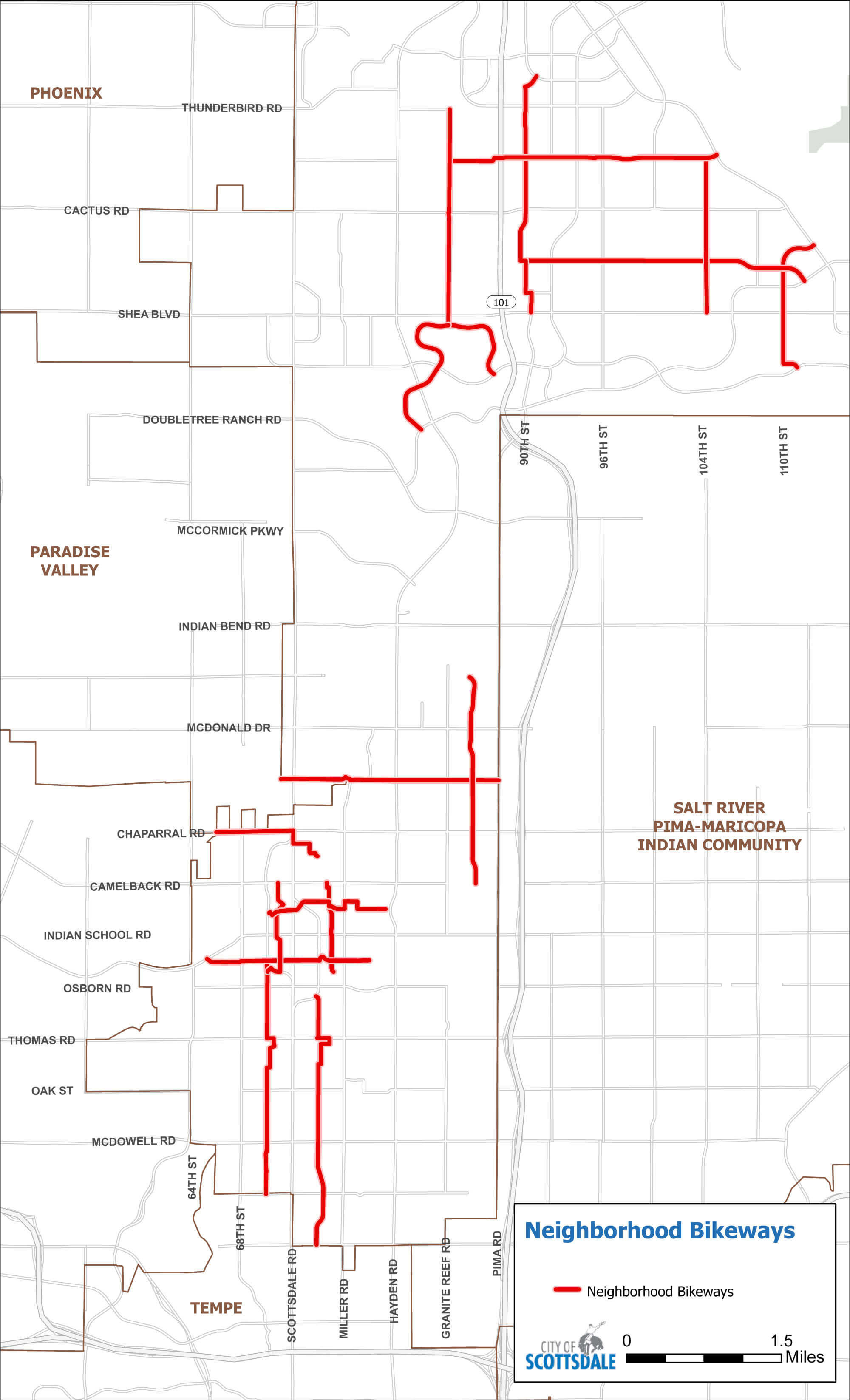
Neighborhood Bikeways are typically found on streets with traffic volumes of under 2,000 vehicles per day (vpd) and residential speeds (25 miles per hour or less) and often contain connections that can only be made by bike or as a pedestrian. They are typically found on the 1/4-mile street network through neighborhoods but feature destinations such as parks, schools, libraries, community centers, religious centers, and medical facilities. They also connect to the rest of the bikeway network. Compared to bike lanes along busier streets, neighborhood bikeways are low-stress and accommodate a wider range of users. They typically have shared lane markings (sharrows) or bike lanes, depending on traffic volumes, and can include signage, traffic calming and enhanced crossings at major streets (see Table B-1 and Figure B-2).
| Street | From - To | Mileage |
|---|---|---|
| 70th St. | Continental Drive to 2nd St. | 2.4 |
| 70th St. | Potential Extension | 0.4 |
| 74th St. | McKellips Road to Thomas Road | 2.0 |
| 74th St. | Potential Extension | 0.5 |
| 84th St. | Shea Blvd. to Thunderbird Road | 2.5 |
| 86th St. | Camelback Road to Lincoln Drive | 2.0 |
| 86th St. | Potential Extension | 0.5 |
| Arabian Trail | Via Linda to Mountain View Road (east) | 2.5 |
| 90th St. | Shea Blvd. to Redfield Road | 2.4 |
| 104th St. | Shea Blvd. to Sweetwater Ave. | 1.5 |
| 110th St. | Mountain View Road to Frank Lloyd Wright Blvd. | 1.5 |
| Jackrabbit Road | Scottsdale Road to 87th Terrace | 2.0 |
| Cholla St. | 89th St. to Via Linda | 2.8 |
| Sweetwater Ave. | 84th St. to Frank Lloyd Wright Blvd. | 2.6 |
| 2nd St. | Indian Bend Wash to Crosscut Canal | 1.6 |
| Glenrosa St./5th Avenue | Indian Bend Wash to Arizona Canal | 1.4 |
| Chaparral Road/Rancho Vista Drive | 64th St. to Arizona Canal | 1.2 |
| 70th St./Marshall Way | Osborn Road to Camelback Road | 1.1 |
| 75th St. | 2nd St. to Camelback Road | 0.9 |
| Total: | 31.8 | |
Shared Use Paths
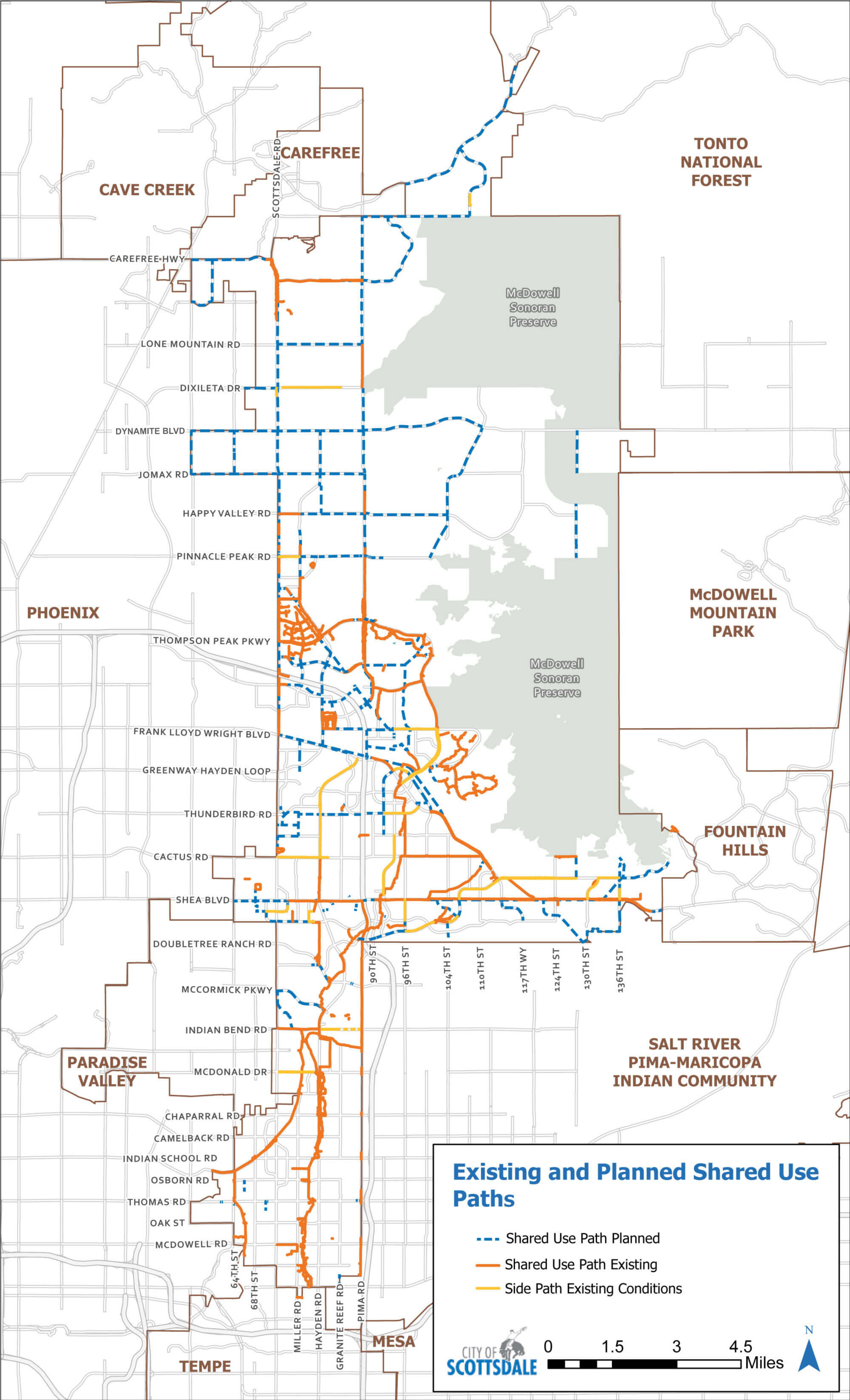
The existing and planned shared use path network is shown in Figure B-3. These paths link to the on-street network while providing connectivity to a wider range of bicyclists. They also feature grade-separated crossings in many locations. Segments are prioritized for construction based on three criteria: the potential demand in the vicinity of the corridor, the existing bicycling conditions on parallel roadways and the potential for connections to the city’s existing bicycle network. The availability of grant funding is also considered.
Primary Shared Use Paths
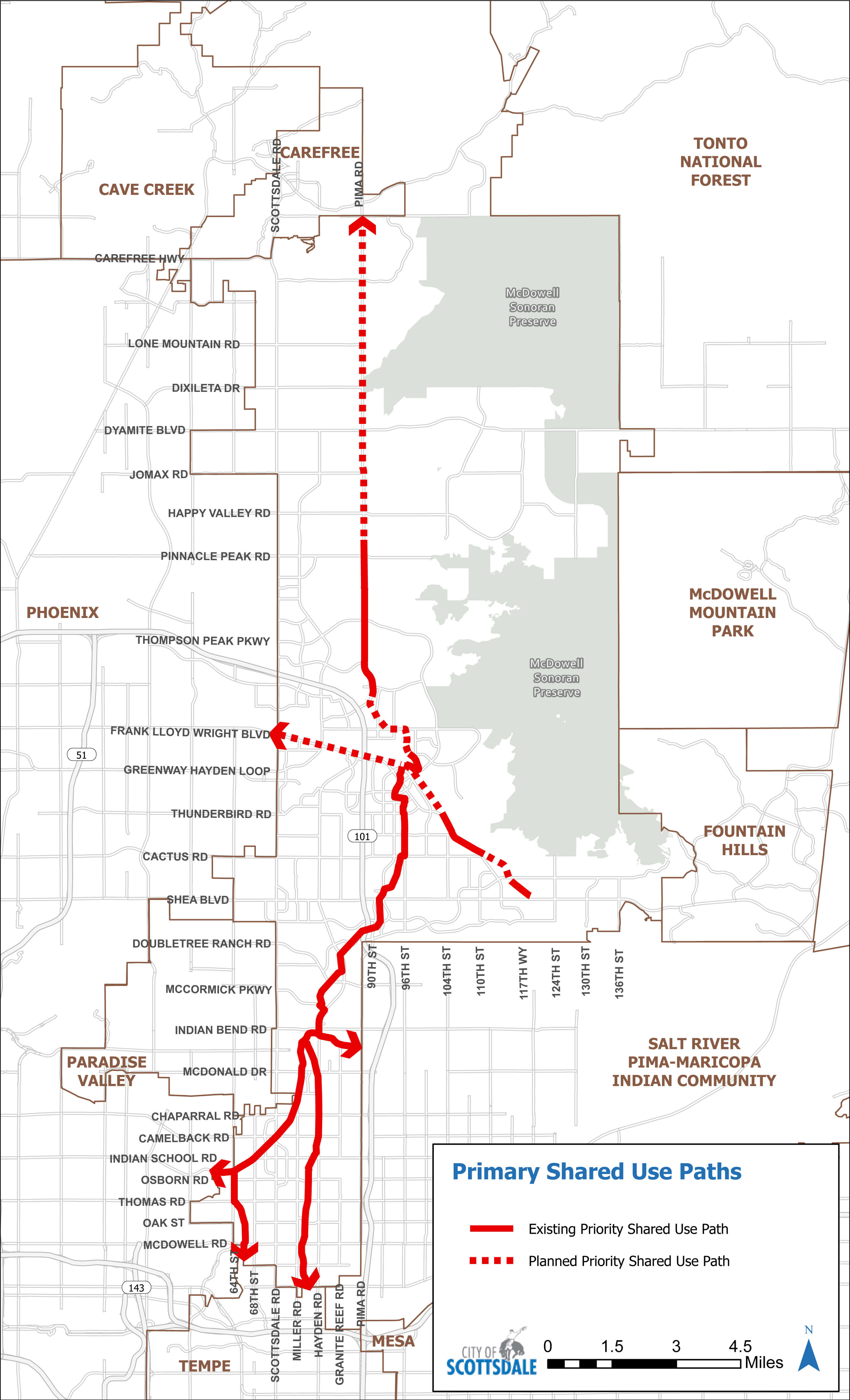
Three primary shared use paths serve as the spine and main linkages throughout Scottsdale: the Indian Bend Wash (IBW) Path, the Crosscut Canal Path/Arizona Canal Path and the Central Arizona Project (CAP) Canal Path. Each provides local and regional connectivity and is a high priority for implementation. More details on the three primary paths are provided below and shown in Figure B-4:
Indian Bend Wash (IBW) Path:
The IBW path runs north/south and links to the city of Tempe and the town of Carefree. Approximately 15 miles of path exist from McKellips Road to the WestWorld area, which is the approximate center point of the IBW Path. The northern section is approximately 13 miles long, of which 3.5 miles is constructed between Trailside View and Pinnacle Peak Road, while the rest is planned.
Crosscut Canal Path/Arizona Canal Path:
The 1.8-mile Crosscut Canal Path connects to a path in Tempe and to the 5.8-mile Arizona Canal Path, which connects to Phoenix and the Salt River Pima Maricopa Indian Community. Both canals are paved throughout Scottsdale.
Central Arizona Project (CAP) Canal Path:
As part of a regional planned path, Scottsdale’s 9.2-mile planned path runs along the south side of the CAP Canal, primarily along adjacent developed land. Approximately 2.2-miles of the path are complete east of Loop 101 along the Frank Lloyd Wright Blvd. corridor. This path connects to city of Phoenix and the Salt River Pima-Maricopa Indian Community.
Non-Primary Shared Use Paths
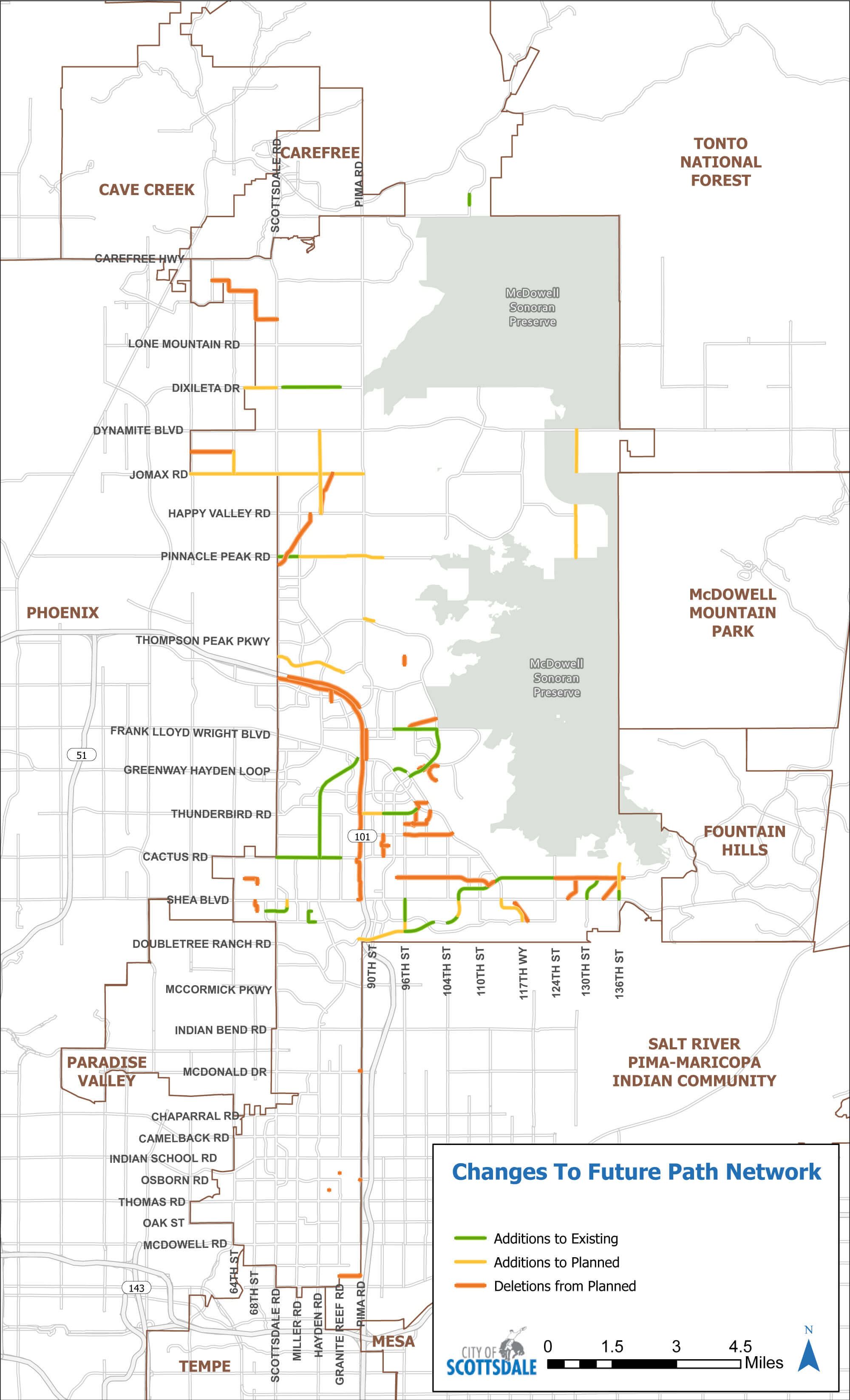
Changes to the future non-primary path network are broken into three categories: additions to the planned system, additions to the existing path system and deletions from the planned path system. These changes represent a net change of 12 additional path miles. These changes are shown in Figure B-5.
Performance Measures
- Reduce citywide per capita bicycle collision occurrences, based on six-year moving average data.
- Maintain a positive (excellent/good) rating of 70% or better in the National Community Survey for “Ease of Travel by Bicycle.”
- Percentage of residences within ½-mile network distance to a shared use path.
- Mileage of completed shared use paths.
- Mileage of arterial and collector roadways with bike lanes.
- Mileage of completed Neighborhood Bikeways.
- Number of annual bicyclist boardings on transit routes.
- Annual counts from permanent counters, mobile counters, and third party vendors.
Last Updated: May 16, 2024


